
The technical staff at SanGIS is available to create custom maps to meet your needs in either hardcopies or digital formats, and can laminate and mount it.
Please contact us with any question about your project needs or use the online Map Request Form.
Learn more about the SanGIS services and view samples of our work here.
Our technical staff can use over 400 digital map layers from our in-house spatial data warehouse to create a map to meet your needs. The spatial data warehouse layers cover a wide variety of information about San Diego County and includes cities, county supervisor districts, city council districts, community planning areas, zip codes, law beats, etc. as well as parcels, roads, and addresses.
SanGIS offers five standard map template sizes (landscape or portrait) with or without aerial photo backdrops. Pricing is based on map size and the inclusion of aerial photography. See the Map Samples page for examples of maps we could make for you - aerial imagery, zoning, parcels, topography (also known as topo or contours).
Maps are usually provided digital format (e.g. pdf, png) but we can also print hard copy maps. See the Price List for current pricing.
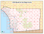
SanGIS offers the 7.5-minute quadrangle series USGS topographic maps for an area slightly larger than the County of San Diego.
The 7.5 quad maps are the best known of the maps offered by USGS. These maps are in GeoPDF format and printable at full 1:24,000 scale on a 23” by 27” sheet. Maps can be printed with or without aerial imagery and layers can be turned on and off.
|
|
|
Maps which require data import or map layer creation, special sizes, special logos or other non-standard items are available on a time and materials basis. See our Price List for current hourly rates. A 50% non-refundable deposit is required to begin work.
SanGIS provides map plotting services for static maps. A static map is one that is available only as a digital image (such as JPEG or PDF) with a fixed size, a fixed set of data, and that has already been "plotted" digitally. See the Price List for costs. You can find many maps developed by our City and County JPA members on our GIS Links page.
Please Note: Pricing for static map reprints does not cover interactive map sites (those map sites where you can pan, zoom, add or delete data layers, etc.). SanGIS can still help you with plotting from interactive mapping sites but we charge at the Non-Standard Map rate.