
SanGIS can create a custom map for you using over 500 different data sets. These maps can include vegetation, flood plains, parcels, roads, legislative districts and much more. Included here a few samples of maps commonly requested. Most of the maps requested are centered around a certain parcel or set of parcels and these samples reflect that theme. However, many other combinations are possible so just contact us to discuss your particular need.
| Sample Map Description | Sample Map PDF |
|---|---|
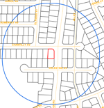
Parcel with bufferExample of a 500 foot buffer around a single selected parcel. Shows what other properties are within a certain distance of the edge of the selected property. |
 |
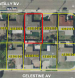
Parcel with aerial imageMap of parcels in an area with an aerial imagery backdrop. SanGIS has aerial imagery from as far back as 2000 (limited to some areas in some years). |
 |
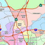
San Diego City Planning AreasThis is not a parcel-based map. This map shows Community Plan boundaries within the City of San Diego. Frequently requested by civic groups for planning purposes. |
 |
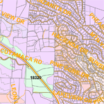
VegetationThis map shows roads, parcels, and vegetation types in a sample area of San Diego County. Provides an example of how colors can be used to highlight different categories of features. |
 |
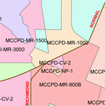
Zoning mapA sample showing zoning in a portion of the City of San Diego. Uses both labels and colors to identify different zoning categories. This differentiation can be applied to many layers in the SanGIS data warehouse. |
 |
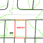
Contours (topography or topo)Simple map showing a selected parcel 2 foot contour lines. This is frequently requested as a topography or “topo” map. Other contour intervals are also available and frequently used when larger areas are mapped. |
 |
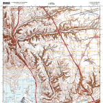
USGS 7.5’ Quadrangle MapOne of 115 USGS Quad maps available from SanGIS. These GeoPDF maps have 15 or more layers that can be turned on and off. Aerial imagery can be added as a backdrop. These are the same maps available from USGS and are the most recent updates to this popular series. |
 |