
March 14, 2017
In late 2015 the Federal Emergency Management Agency (FEMA) collected LiDAR data for the middle, rural, area of San Diego County. The LiDAR data was used to generate 5 foot contours over the covered area. SANDAG has coordinated delivery of the contour data to SanGIS and other outlets. The contour data is now available for download on the SanGIS/SANDAG Regional Data Warehouse.
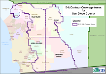
The contour data was developed from a Quality Level 2 LiDAR collection (2 points/sq meter) across the (approximately) middle third of the County. The data cover the area east of the incorporated jurisdictions to approximately the ridge of the Laguna Mountains.
Due to the dataset size and limitations of the standard ESRI Shape File format, the contour data has been published as 4 separate datasets in ESRI’s File Geodatabase format. The datasets can be found under the Topography category in the Regional Data Warehouse. The coverage areas can be found in the Grid category (look for the GRID_2015_5ft_Topo_Index dataset). The coverage areas are also shown in the PDF image at right. In addition to the contour data, a new Digital Elevation Model (DEM) was created. This data is available from SanGIS for the cost of media and extraction services. Contact SanGIS if you would like to acquire the DEM or if you have questions about the new contour data. |
 |
SANDAG is currently working on a project to collect LiDAR data for the remaining eastern third of the County. Contours and digital elevation models will also be produced from that collection. The new data is expected to be available sometime in late 2017 or early 2018.