
December 2, 2015
In November 2014 SanGIS, SANDAG, the National Geospatial Intelligence Agency (NGA), the San Diego Law Enforcement Coordinating Council (LECC), the Regional Public Safety GIS and all 18 incorporated cities in the County, collected LiDAR data for the western, urbanized, area of San Diego County. The LiDAR data was used to generate 2 foot contours over the covered area. The contour data is now available for download on the SanGIS/SANDAG Regional Data Warehouse.
The contour data was developed from a Quality Level 2 LiDAR collection (2 points/sq meter) across the (approximately) western third of the County and for a portion of northwestern Baja California, Mexico – primarily the Tijuana area.
|
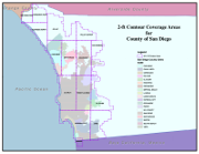
Due to the dataset size and limitations of the standard ESRI Shape File format, the contour data has been published as 15 separate datasets in ESRI’s File Geodatabase format. The datasets can be found under the Topography category in the Regional Data Warehouse. The coverage areas can be found in the Grid category (look for the GRID_2014_2ft_Topo_Index dataset). The coverage areas are also shown in the PDF image at right. In addition to the contour data, a new Digital Elevation Model (DEM) was created. This data is available from SanGIS for the cost of media and extraction services. The DEM is also available as an image service from SANDAG. Contact SanGIS if you would like to acquire the DEM or if you have questions about the new contour data. |
 |
The 2014 contours can be used in standard and custom maps made here at SanGIS or you can order a print of just the area you need.