SanGIS has recently acquired the 7.5-minute quadrangle series USGS topographic maps for an area slightly larger than the County of San Diego. These are the latest updates to the USGS’ famous topo map series and are the same as the maps available for download from the USGS web site.
The 7.5 quad maps are the best known of the maps offered by USGS. They provide a variety of detailed information for categories such as: Bathymetric and coastal features, boundaries, contours, buildings and related features, control data and monuments, projections, public land surveys, railroads, rivers and lakes, roads and other transportation features.
These maps are in PDF format and printable at full 1:24,000 scale on a 23” by 27” sheet but we can put them on smaller or larger sheets if needed. SanGIS can print these maps as is and with or without an aerial imagery backdrop. Because of the way the maps are made certain features can be turned on or off to create just the map you need.
Prints of full scaled maps (23” x 27”) for $15 and oversize prints (33” x 44”) for $20 can be obtained from our technical staff at SanGIS. Just contact us for more information or come by to order your maps today. Select the map you need by name from the Grid (see figure 2) and let us know the size you want and whether you would like it laminated or mounted on foam core board.
See the USGS publication USGS Topographic Map Symbols.pdf for a complete list of map features and symbology. Click on the sample image above (figure 1) to view a sample the USGS GeoPDF maps.
|
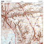
Figure 1 – GeoPDF USGS Quad
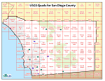
Figure 2 - Quad Grid Map
|
