
January 14, 2013
SanGIS has taken delivery of ortho-rectified aerial imagery flown in May 2012 covering the entire County of San Diego. This imagery was acquired through a regional effort in conjunction with SANDAG, the National Geospatial Intelligence Agency (NGA), the San Diego Law Enforcement Coordinating Council (LECC) and Regional Public Safety GIS (see the full article on the acquisition partnership on our News and Information page). The regional effort to acquire this imagery had the advantage of not only spreading the cost among agencies but also of limiting licensing restrictions. The 2012 imagery is in the public domain and use is not restricted by license limitations. The imagery will also be available through the USGS (see their Maps, Imagery, and Publications website).
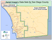
The imagery available is at 30 cm (1 foot) resolution in the incorporated areas of the county and 50 cm (½ meter) resolution in the unincorporated areas. The higher resolution imagery covers approximately the Western third of the county – the urbanized area – and the ½ meter resolution covers the remaining, rural, areas. See the map below for the approximate boundary of the two data sets.
|
The 2012 imagery can be used in standard and custom maps made here at SanGIS or you can order a print of just the photo for the area you need. The imagery will also be used on our new interactive map once we have completed the necessary development and image processing. The imagery is also available in its raw form for your use. SanGIS has the raw GeoTIFF tiles and in compressed MrSID format. Indexes of the GeoTIFF and MrSID files are available in Shape File format from the Regional Data Warehouse under the GRID category. You can order just the tiles you need, or the entire data set, by contacting SanGIS. See our Services page for ordering information or contact us for details. Note that the aerial imagery data files can be quite large. The table below gives an idea of the size of the files in either GeoTIFF or MrSID format. |
 |
| Data Set | Item | 30 CM | 50 CM | Totals |
| GeoTIFF | Total number of tiles | 1836 | 3425 | 5261 |
| Size per tile (Megabytes) | 95.42 | 34.36 | ||
| Total for all tiles (GB) | 171.09 | 114.91 | 286 | |
| MrSID | Total Number of Tiles | 9 | 4 | 13 |
| Maximum File Size (GB) | 1.26 | 1.58 | ||
| Total for all tiles (GB) | 7.38 | 4.69 | 12.06 | |
| Totals | Tiles and MrSID Files (GB) | 178.46 | 119.6 | 298.06 |